Toronto releases map of COVID-19 neighbourhood hot spots throughout the city
Toronto Public Health just released a detailed map of all COVID-19 cases in the city by neighbourhood, and it reveals that low-income areas have been disporportionately affected by the virus.
Speaking at the city's daily press briefing Wednesday afternoon, Mayor John Tory said he hopes the new information will do "far more help than it will do harm," addressing concerns that releasing this data could lead to the stigmatization of certain neighbourhoods.
"It was information that I requested she bring forward… on the basis that it would help us fight the spread of the virus and, just as importantly, to support neighbourhoods and people affected by the virus," he said.
"This is about human beings who've tested positive — fellow Torontonians who live with us in our city and who live in areas that have been affected more so, perhaps, than others."
Looks like the city of Toronto has released neighborhood maps showing the number of confirmed COVID-19 cases. Clear class/SES gradient. https://t.co/UjL9lrFgk2 pic.twitter.com/ASHh0ig3N8
— Arrianna Marie Planey, PhD (@Arrianna_Planey) May 27, 2020
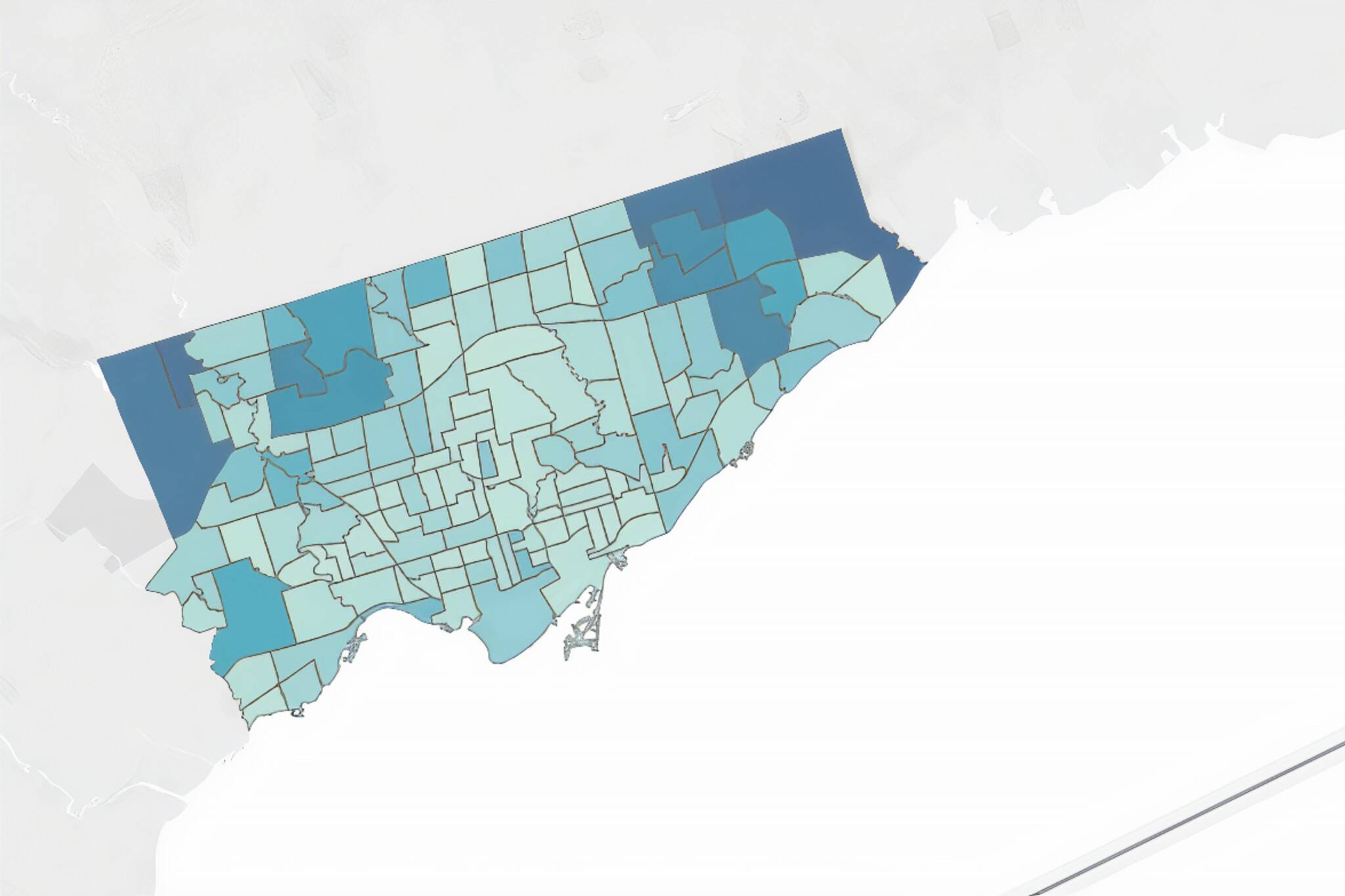
The interactive map, which was posted to the City's website, shows that neighbourhoods in the northwest and northeast parts of the city now have the highest number of positive cases.
Mount Olive-Silverstone-Jamestown has the second-highest number in Toronto with 384 total cases, while Rouge has the highest number in the city with 400 cases.
Other neighbourhoods that have been disproportionately hit include Milliken (365 cases), West-Humber Clairville (357 cases), Agincourt North (301 cases), Agincourt South-Malvern West (301 cases), Woburn (325 cases) and Glenfield-Jane Heights (305 cases).
The neighbourhood data shows highest case rates in northwest and northeast areas of the city. The correlation between this map and the city’s income map is striking. pic.twitter.com/Ntb1lmwbwN
— Matt Elliott (@GraphicMatt) May 27, 2020
During Wednesday's press briefing, Toronto's Medical Officer of Health Dr. Eileen de Villa reminded people that where a person lives does not necessarily indicate where they picked up COVID-19, and that areas with lower rates are not inherently safer.
"These numbers represent people, people in our city," she said. "It is important to keep in mind that these maps reflect where people live and they do not necessarily reflect where they were exposed."
She also said the decision to release this data to the public was made in order to aid the city's COVID-19 response by making it easier to identify where proactive testing would be helpful and where targeted preventive actions are needed.
She added that the city will continue to update the map going forward.
As of May 26, 7,814 people have recovered from #COVID19 in Toronto, +187 since May 25. Get more details on the status of cases in our city: https://t.co/5owLsFBxXT pic.twitter.com/rS5VwyKwik
— Toronto Public Health (@TOPublicHealth) May 27, 2020
Activists, journalists, public officials and other experts have long been saying that this virus has disproportionately affected low-income and marginalized people, many of whom are the essential workers who've kept society running throughout lockdown measures.
This is also the reason why there have been constant calls for the collection of race-based data in Canada, something both the City and the province are now doing as a result.
Similarly to the map, data collected and released by TPH earlier this month revealed that neighbourhoods with the lowest incomes, highest rates of unemployment and highest concentrations of immigrants had double the number of cases as well as twice the rate of hospitalizations.
"We found that the lowest income group (the quintile with the highest percent of people living below the low-income measure) had the highest rate of COVID-19 cases. It had 165 cases per 100,000 people, compared to the rate in the highest income group, with 90 cases per 100,000 people," reads the report.
Meanwhile, Dr. de Villa said today that the new map will serve as a tool to address these inequities that are clearly prevalent within Toronto.
"We all have a shared responsibility to not create unnecessary social, physical or other harms in our community," she said. "I've said this many times before, but I think it is important to remind ourselves again that these cases are our friends, they are our colleagues and they are our family members."
Latest Videos
Latest Videos
Join the conversation Load comments