This is what the TTC subway map could have looked like by now
With the seemingly daily issues that plague public transit in what is the country's fastest growing city, it's hard not to wonder what things would have been like if some of Toronto's past subway expansion plans had actually come to fruition.
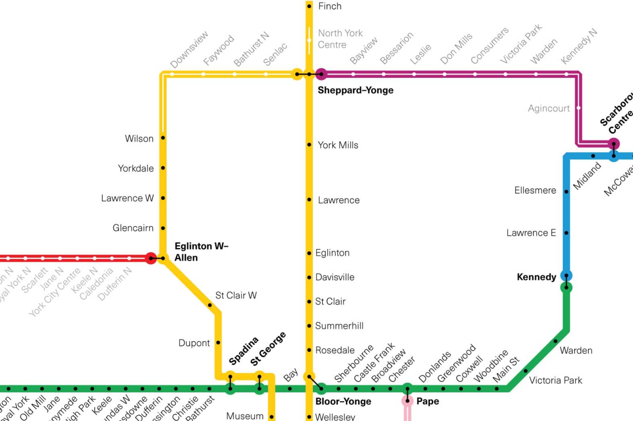
I drew a map of the cancelled 1985 subway expansion plan. from r/toronto
One of the most ambitious proposals, from 1985, would definitely have made current-day commuters' lives a lot easier.
The Network 2011 plan would have seen the addition of three completely new subway lines over the course of the mid-80s to 2011, including a Downtown Relief line connecting some of the city's busiest and most touristy areas — Lower Spadina, the CN Tower, Union Station and St. Lawrence Market — to one another, as well as to both the Yonge-Spadina and Bloor-Danforth lines.
The proposed Sheppard-Yonge line, which is now only comprised of five stops, would have run further east to Scarborough Town Centre, forming a full loop with the Scarborough RT, Bloor-Danforth and Yonge-University lines.
And, an Eglinton West RT line would have run west from Allen Road all the way through Mississauga to Pearson Airport.
When I asked Layton about his stand in 1986 he said a #ReliefLine "doesn't make sense because the trains would be packed from Day 1." He feared "Manhattanization" and apparently believed in the hubris that humans are smart enough to create instant downtowns in suburban locations. https://t.co/QQ79WAWRY3
— Stephen Wickens (@StephenWickens1) October 25, 2018
The project was eventually scrapped by provincial government at the time after numerous delays and revisions, as well as opposition by politicians like NDPer Jack Layton, who wanted to discourage increasing population density in the downtown core and encourage expansion to the suburbs.
The plan did lead to the Sheppard line we know today, as well as the Line 1 extension from Spadina to Downsview.
But, it is a little frustrating to be confronted with a map of what Toronto's subway system could have looked like by now, especially with how many residents take issue with the way our transit system currently operates.
Latest Videos
Latest Videos
Join the conversation Load comments


