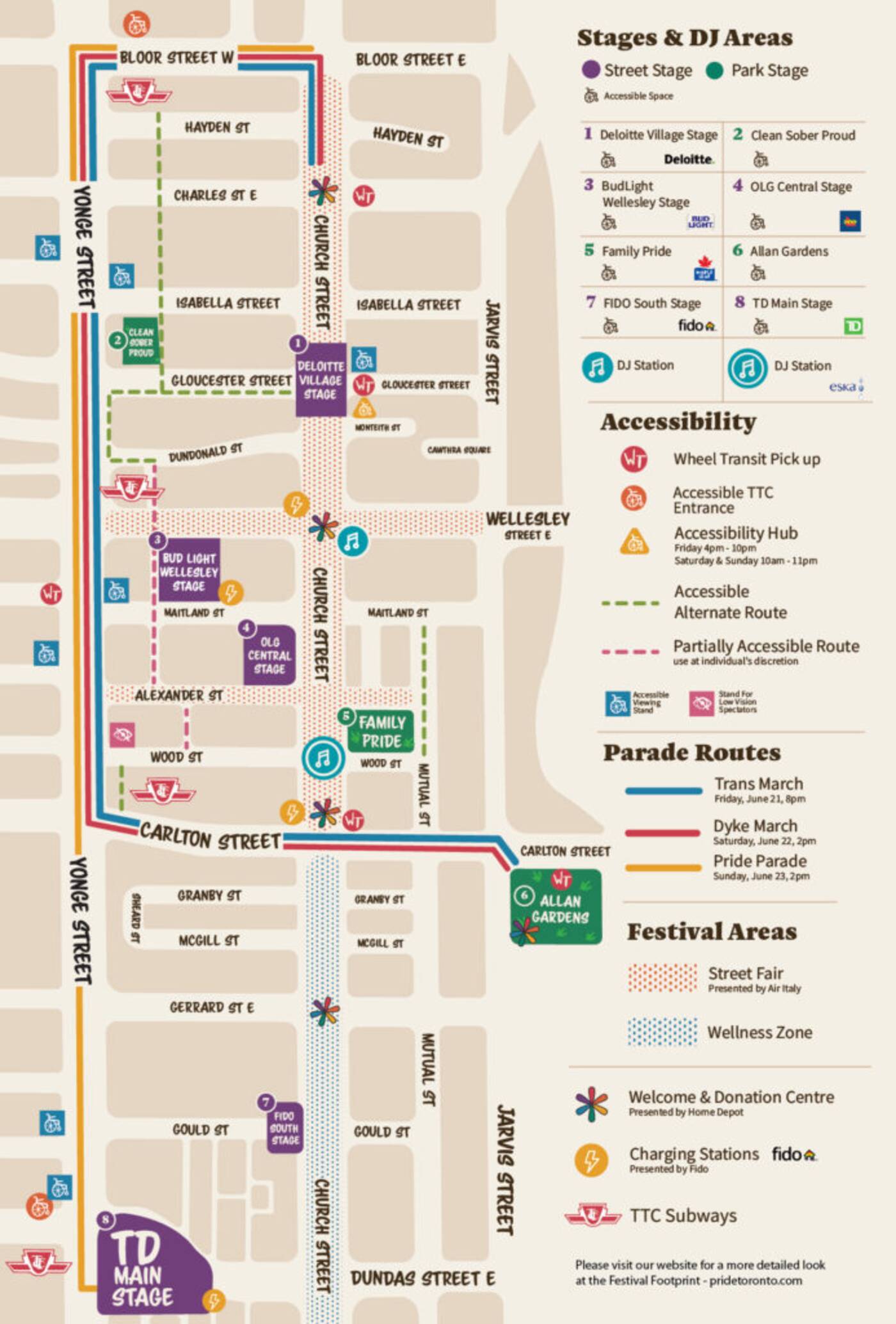
The Toronto Pride Parade route map and road closures for 2019
The Toronto Pride parade route map and list of road closures is what you need to get ready for a big celebratory weekend in the city.
Full road closures and restrictions will start as early as 6 a.m. on June 21 and will be in place until June 24 as late as 6 a.m. to accommodate the festival.
Closures will border an area that includes Bloor Street East to the north, Yonge Street to the west, Church Street to the east and Dundas Street East to the south.
The best thing to do this weekend is ditch the car and get in on all the action.
Here's everything you need to know about the Pride parade, marches, routes and road closures that will be in place for the weekend.
Trans March
A number of full and rolling road closures will be in place on June 21 starting as early as 10 a.m. until as late as 9:30 p.m. Closures will affect portions of Bloor Street East, Carlton Street, Church Street, Hayden Street, Isabella Street and Yonge Street.
Pride & Remembrance Run
The following streets will be affected by rolling and full road closures on June 22 from 8 a.m. to approximately 12:30 p.m.
- Wellesley St. between Jarvis St. and Queen’s Park Cres. West
- Queen’s Park Cres. East between College St. and Charles St. West
- Queen’s Park Cres. West between College St. and Charles St. West
Dyke March
A number of full and rolling road closures will be in place on June 22 for the annual march.
- Portions Hayden St. and Church St. will be closed from noon until approximately 3 p.m.
- Portions of St. Mary’s St., Breadalbane St., Isabella St. and Wood St. will be impacted from 5 a.m. until approximately 9 p.m.
- Rolling closures will be in place on Hayden St., Bloor St. East, Yonge St. and Carlton St. starting at 2 p.m. until approximately 5 p.m. for the march route.
Pride Parade
Road closures will be in place on June 23 starting as early as 5 a.m. until as late as 9 p.m for the parade.
- Impacted roads to accommodate the parade formation, dispersal and route include parts of Bloor St. East, Church St., Dundas St., Park Rd., Rosedale Valley Rd., Victoria St. and Yonge St.
- Other roads impacted by this event include Breadalbane St., Dundonald St., Isabella St., Edward St., Elm St., Park Rd., St. Joseph St., St. Mary’s St., Wood St.
Hector Vasquez
Latest Videos
Latest Videos
Join the conversation Load comments


